IUCN/SSC Otter Specialist Group Bulletin

©IUCN/SCC Otter Specialist Group
Volume 34 Issue 1 (January 2017)
Citation: Mgoola, WO and Msiska, HG (2017). The Status and Distribution of the Clawless Otter (Aonyx capensis) in Vwaza Marsh Wildlife Reserve and Nyika National Park, Northern Malawi. IUCN Otter Spec. Group Bull. 34 (1): 3 - 17
The Status and Distribution of the Clawless Otter (Aonyx capensis) in Vwaza Marsh Wildlife Reserve and Nyika National Park, Northern Malawi
William O. Mgoola1 and Hetherwick G.Msiska1
1 Department of National Parks and Wildlife, Vwaza Marsh Wildlife Reserve, Box 170, Rumphi, MALAWI. e-mail: hgmsiska@gmail.com, wmgoola@yahoo.co.ukwmgoola@yahoo.co.uk
| (Received 2nd September 2016, accepted 28th December 2016) |
| Download PDF (598 KB) |
| Abstract: The clawless otter (Aonyx capensis) occurs in Nyika National Park and Vwaza Marsh Wildlife, Northern Malawi. A number of rivers, streams and other wetlands areas were searched for otter signs (spraints, tracks, dens, runs, food remains). The species status in Nyika could be rated as common and sparse in Vwaza. The clawless otter commonly occurs in Nyika; all the wetland areas surveyed indicated positive otter signs. A total of 790 signs were recorded in Nyika National Park, these signs were registered most frequently in riverine habitats in northern hills, followed by montane riverine habitats on plateaus and southern hills wetlands. There is no significant difference in density of otter in Nyika Wetlands (F=2.636 df= 2 and 6; P˂0 .001). This area has high potential for the survival of the clawless otter. There is abundant otter prey (fish, crabs), adequate vegetation cover, water, and reduced human activity. Aonyx capensis in the Vwaza Marsh Wildlife Reserve were recorded only in the marsh (247 signs) and very rare in downstream areas. Luwewe and South Rukuru rivers remained negative with no evidence of otter occurrence. The habitat in the marsh is ideal for the survival and existence of otters, adequate vegetation cover, water and prey. The main threats observed in Nyika National Park include illegal bushfires, fish poaching especially in northern hills wetlands, and soil erosion. The major factors of stress in Vwaza Marsh Wildlife Reserve are streambank cultivation, riparian vegetation destruction, siltation, illegal bushfires and competition for fish and crabs between humans and otters. Broad-based conservation measures are proposed for long term survival and existence of clawless otter and its habitats. |
| Keywords: Clawless otter, spraints (scats), holts, tracks, habitat |
| Française | Español |
INTRODUCTION
The Cape clawless otter ( Aonyx capensis ), belonging to the family Mustelidae and Order Carnivora, has received no formal scientific research on its status and distribution in Vwaza Marsh Wildlife Reserve and Nyika National Park in the northern region of Malawi. The knowledge of the species is traditionally widespread amongst protected area staff as well as rural people bordering the protected areas. Small mammal conservation has taken a back seat to general conservation measures that emphasize large mammals. Otters locally known as Katumbwi or Katumbu (Tumbuka and Chichewa local names for otter respectively) are known to occur in the wetlands of Malawi, and there are two types, the cape clawless otter and the spotted–necked otter. The former is the larger of the two and has dark brown back and head with contrasting white neck and under parts whereas the latter has brown upper parts and its under parts pale but strongly mottled with brown spots. Hough (1989) reported that the distribution of the clawless otter is probably widespread in Nyika National Park and Vwaza Marsh Wildlife Reserve whereas the Spotted-necked otter is absent. Some community members in the northern part of Vwaza reported having their fishing baskets destroyed by otters hunting for food. Otters have been observed feeding on trout in Nyika (Mill, 1979). Husson et al. (1997) recorded some otter signs in the northern hills of Nyika National Park. The primary living requirement for otters in freshwater habitats is unpolluted, unsilted water in which crabs, fish, and frogs occur (Nagulu et al ., 1998; Rowe-Rowe, 1992). The International Union for Conservation of Nature (IUCN) Otter Specialist Group also underscores the fact that otters play a significant role as indicators of the health of the wetlands they inhabit (Butler and Hillman, 1995). In light of this, presence of otters in a river or stream reflects healthy aquatic conditions. Nyika and Vwaza protected areas were established to conserve and protect biological diversity of fauna and flora. Additionally the majority of the local communities in the border zone depend on these protected wildlife areas for their livelihood in terms of water for domestic and agricultural purposes downstream. The protected areas are of extreme economic importance to northern Malawi as the main reserv oir of dry season water supply.
In recent years there has been growing recognition that the earth is facing a loss of biological diversity of crisis proportion (Wilson et al., 1996). The ever increasing pressure of human population growth has led to worldwide habitat degradation that has driven many known and unknown plant and animal species to extinction and put numerous others at risk. This dilemma has focused attention on the need to survey biological resources as a first step in developing management strategies essential for establishing legislation and other guidelines to save biological resources for the future. Otters are some of the endangered and threaten mammal species in Malawi due to habitat loss which is linked to human population growth. Smith (1992) documented of negative human impacts in the Otter Point area of Lake Malawi National Park. The Cape clawless otter and Spotted-necked otter are known to inhabit large rivers and their associated tributaries, estuaries, swamps and requires undisturbed riparian forest vegetation with long grass, reeds and bushes to provide cover for resting places and holts (Rowe-Rowe, 1992). Sweeney (1966) indicated that the Cape clawless otter in Malawi is more common than Spotted-necked otter and that it occurs in marshy places at lower levels in small streams while the latter is restricted to larger rivers and lakes. Otters are rarely seen and as such indirect methods of observations using sign are widely used. The spraints or scats are normally deposited on easily recognized sites, on grassy mounds near the seashore, at the mouth of rivers; under bridges and at the entrance to holts (Yoxon, 1998). Signs such as spraints (scats), dens (holts) and tracks have been used by various otter scientists in wetlands to assess the distribution or habitat use (Romanowski and Brzezinski, 1997).
Assessment of mammal diversity focuses on the broad distributional patterns of mammals in relation to natural and human landscape elements (Wilson et al., 1996). By obtaining information on mammal distribution, natural landscape elements and human influences at any given site, many questions relevant to the understanding and conservation of mammals' diversity can be addressed. There is no information available regarding the status and distribution of otters in Nyika and Vwaza since the two were designated as protected areas. Sound management conservation measures can only be made on the basis of information. The key to successful management of park resources is an understanding of the structure (baseline inventories) and function (ecosystem dynamics) of the ecosystems and the transformation of these into a flexible mechanism for decision making (Mill, 1979). Consequently, a survey was undertaken from May 2000 to February 2001 in the two protected areas in order to ascertain the otter status, identify localities they inhabit, major threats endangering their survival and conservation measures that can be undertaken to enhance otter survival and protection of habitats.
STUDY AREAS
The survey was carried out in two protected areas in the northern region of Malawi.
 |
| Figure 1. Map of Malawi and National Parks (click for larger version) |
Vwaza Marsh Wildlife Reserve
Vwaza Marsh Wildlife Reserve is located in the Central African Plateau, west of Northern Malawi (Figure 1) and covers an area of 986 km². It lies on the watershed between Lake Malawi and the Luangwa valley, Zambia [33º 28'E / 11º 00'S] and the western part of its boundary coincides with Malawi – Zambia border (Clarke, 1983). The reserve has three major landscape types namely the plateau on the western sector, hills and pediments occupy the eastern half of the area whereas the wetland-alluvial types is found on the north-central and southern boundary of the area (McShane, 1985). Three major wetland areas were surveyed (Figure 2), marsh, Luwewe and South Rukuru dambo-floodplains including Zaro pool and Lake Kazuni. Luwewe river has an average width of 8m, depth 1.5m and runs in a north –south direction forming a seasonally flooded belt. It ceases continuous flow as soon as the rainy season has come to an end thereby leaving water pools in certain portions. The riverbanks are characterized by tall grasses ( Hyparrehnia species) with a narrow strip of riverine forests dominated by Syzigium quineense lining its entire channel. South Rukuru river forms the southern boundary of the reserve and is the principal river draining the majority of the reserve. Its banks are open due to widespread streambank cultivation by the adjacent local communities. It is characterized by seasonally inundated floodplain grassland dominated by Hyparrehnia species with scattered trees mainly Acacia species on raised alluvial edges. The river width ranges from 8m to 13m with an average depth of 3m. The marsh, the major otter locality is dominated by dense papyrus marsh ( Cyperus papyrus) with patches of bulrush (Typha austriralis) and reeds (Phraggmites mauritians). It comprises four main streams, Hewe, Chamatete, Kaling'ondo and Dera. The mean depth is 1.6m and width 5.6m. It supports a high density of freshwater river crabs (Potamomaues species) and catfish (Clarias gariepinus). The area is a waterlogged alluvial basin holding water throughout the year.
 |
| Figure 2. Distribution of otter signs in Vwaza Marsh Wildlife Reserve (click for larger version) |
The altitude of the reserve varies from 1082m to 1160 m above sea level. Mean annual rainfall ranges between 700 mm to 1100 mm. Rainfall occurs from November to April. Annual mean temperatures range between 16 ºC to 28 ºC. Temperatures are lowest during early dry season (May to August) and highest in late dry season (September to November).
Nyika National Park
Nyika National Park (3132 km²) is the largest protected area in Malawi. It is centered on 10º 33’S; 33º 50’E and occupies a track of montane plateau and associated hills and escarpments in Northern Malawi (Clarke, 1983). Part of its western boundary coincides with the Malawi – Zambia border.
There are four different vegetation communities, each supporting a different complement of plants and animals. These are Brachystegia woodland, montane grassland (dominates 90% of the plateau, dambos and montane evergreen forests. The valleys between the grassland slopes harbor dambo vegetation community. The dambo grassland is characterised by sedges and herbaceous plant growing in tussocks. A total of eleven major rivers and streams were sampled on the plateau, northern and southern hills of the park (Figure 3). These included North Rukuru, Chilinda-Rumphi, Runyina, Dembo, North Rumphi and Manyenyezi on the plateau. In the northern and southern hills, Chipome, Ulovi, Matolo, Kaswerera, Lusero, Lutete and Runyina were sampled. The riverine vegetation on the plateau is dominated by sedges (Xyris species, Carex species) and grasses typical of the moist habitat such as Setaria longisetta associated with a rich variety of herbaceous plants and occasional woody shrubs. Scattered evergreen forest patches are present in most of the river channels. The mean river depth and width was 1.1m and 4.6 m respectively. The northern and southern hills consist of Brachystegia woodland dominated by Acacia and Uapaca species. Vegetation on the stream bank is characterized by dense long grasses (Hyparrhenia species) with patches of reeds. The average river width in the southern hills was 5.4m and depth 1.4m. Rivers in the northern hills had a mean depth of 1.1m and width 6.3m. Most rivers in Nyika have a good supply of different fish species such as montane catfish (Amphilus platyychir), Baribus species and the introduced rainbow trout ( Salmo gairdner) which prefers cool conditions including graspid crabs (Bowden and Mahto, 1999). The altitude ranges between 1600m and 2600m above sea level. The mean annual rainfall varies between from 890mm to 1600mm and annual mean temperatures range between 10 ºC to 20 ºC.
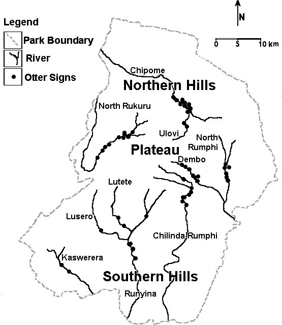 |
| Figure 3. Distribution of otter signs in Nyika National Park (click for larger version) |
METHOD
A total of 74 km of river network was covered during the survey period of which 30km was sampled in Vwaza and 44 km in Nyika. Accessibility in the latter was difficult in some areas due to steep slopes on hills and escarpments. Otters are secretive mammals and indirect method of observation using sign was employed. Rivers, streams, dams and other wetlands areas were searched for otter signs (spraints, dens, tracks, food remains and other indicators) by walking along on both riverbanks (Rowe-Rowe, 1993). The tracks of the clawless otter were differentiated from those of the water mongoose which also appeared to be common in the survey areas. Length and diameter of intact spraints was measured in millimeters and the age of the spraints ranged from very fresh to old. Tracks of the forefoot and hind foot were not differentiated and width was measured at the widest point. Observations were noted with a GPS and marked on a 1:50 000 maps to give a topographically exact picture of distribution. Data sheets principally covering habitat and signs were completed for each observation. Open ended interviews were also carried out among some local fishermen to establish the presence or absence of otters in an area. A total of forty respondents were interviewed especially in Vwaza Wetlands where there is community fishing programme. Depending on the occurrence of positive otter signs, the status of otter population was categorized as common or sparse. All mean are given ± Standard Deviation (Hayslett and Murphy, 1968). Analysis of variance was applied to compare density of otter signs in Nyika Wetlands.
RESULTS
The otter species occurring in both study areas is A. capensis. Its status in Nyika could be rated as common and sparse in Vwaza. All the eleven river sampled in Nyika had positive signs of A. capensis. Regarding habitats, signs were registered most frequently in riverine habitats in the northern hills (Table 4b), followed by montane riverine habitats on the plateau and the southern hills. Of the three wetlands areas surveyed in Vwaza, only the marsh indicated positive otter signs (Table 4a). The habitat is ideal in terms of cover and food availability. Luwewe and South Rukuru rivers remained negative with no evidence of otter occurrence.
|
|
|||||||
| Table 1: Percentage of the total Aonyx capensis signs recorded in each study area | |||||||
|
|
|||||||
| Wetland area | Total otter signs | Spraints | Tracks | Food remains0 | Runs1 | Rolling places2 | Dens3 |
| Vwaza | 247 | 55.5% | 36.4% | 2.4% | 5.7% | - | - |
| Nyika | 790 | 60.4% | 28.7% | 4.6% | 4.1% | 1.6% | 0.6% |
|
|
|||||||
| 0Includes crabs and fish remains 1Paths regularly used by otters 2Areas of flattened grass or sand where otters have rolled to groom themselves 3Holes used by otters |
|||||||
|
|
|||||||
A total of 247 Aonyx capensis signs were recorded in Vwaza (Table 1) and most of them were found along riverbanks. The majority of these were scats (55.5%) (Figure 2), followed by tracks (36.4%), runs (5.7%) and food remains (2.4%). Twenty three spraints sites were identified and all occurred in the northern section of the reserve (Table 2a and 4a). The mean for spraints sighted was 6.85 ± 6.16 (n=20), mean length 59.10 ± 17.30 (n=10) and mean diameter of 23.40 ± 3.86mm (n=10) (Table 2a). Most of the spraints were deposited on grass and sometimes on raised ground along the riverbanks. The tracks were clawless and mean width was 56.07 ± 15.72 mm (n=15).
All the respondents fishing in the marsh (100%) (Table 2b) indicated having seen otters or signs. In South Rukuru and Luwewe wetlands, 90% of the fishermen mentioned of not having seen otters or their signs. Of the fishermen who saw otters in the marsh, 50% indicated that it had a brown back with white throat which are the colour characteristics of the clawless otter. The majority of respondents in South Rukuru and Luwewe wetlands (60%) explained that otters were seen in the past and now are very rare. On the other hand, fishermen in the marsh see otters or their signs frequently.
Aonyx capensis signs in Nyika totaled 790 of which 60.4% were scats, (Table 1), 28.7% (tracks), 4.6% (food remains), 4.1% (runs), 1.6% (rolling places) and dens 0.6%. The mean width of tracks recorded is not very much different from that observed in Vwaza, 53.52 ± 12.67mm (n=42) (Table2c). Mean length for spraints was 47.14 ± 16.02mm (n = 29) and mean diameter 20.70 ± 6.39mm (n=27). The mean for scats sighted was 8.37 ± 9.45 (n=57). Scats observed on the plateau were mostly found on riverine rocks while those recorded in northern and southern hills were deposited on grass along the riverbanks. Furthermore, the majority of food remains recorded on the plateau were sighted on riverine rocks.
Nyika National Park registered the highest number of otter signs observed per km travelled (Table 3). The densities for spraints and tracks were 10.84 and 5.16 respectively. On the other hand in Vwaza Marsh Wildlife Reserve densities of 4.57 spraints and 3.00 tracks per km travelled were recorded.
Distribution
In Vwaza Otter signs were recorded mainly in the marsh, the northern part of the reserve and are very rare downstream. Luwewe river which rises from the marsh and the southern part of the reserve (Figure 1, Table 4a). The marsh is the major otter locality in Vwaza Marsh Wildlife Reserve.
Otter signs are common in Nyika (Figure 3, Table 4b). All the wetland areas sampled indicated positive otter signs. The highest density of signs was recorded in northern hills and the riverine habitats are ideal for otter survival, adequate bush cover and otter prey. The plateau and southern hills wetlands also indicated positive otter signs. However, there is no significant difference in density of otter signs (Table 4b) in northern, southern and plateau areas [F=2.636; df=2 and 6; P < 0.001].
Threats
There are a number of threats observed in Vwaza wetlands endangering the survival of Aonyx capensis (Table 5a). These include streambank cultivation along the inlet stream into the marsh, illegal dry season hot fires, habitat destruction as well as siltation. Also the prevalent is competition for fish and crabs between local communities and otters. During interviews with some fishermen and field observations, it was noted that otter destroy fishing baskets of the local people in order to get fish and crabs, their major food items. In order to protect their fish from being eaten by otters, communities construct a dome shaped structure made of vegetation materials to enclose fishing baskets. The method is very destructive as it involves riparian vegetation cutting and channeling of water from the main streams into smaller dug channels for purposes setting basket fish traps (Msiska, 1997).
Soil erosion, illegal dry season hot fires and fish poaching especially in the northern hills were recorded as the major threats in Nyika wetlands (Table 5b).
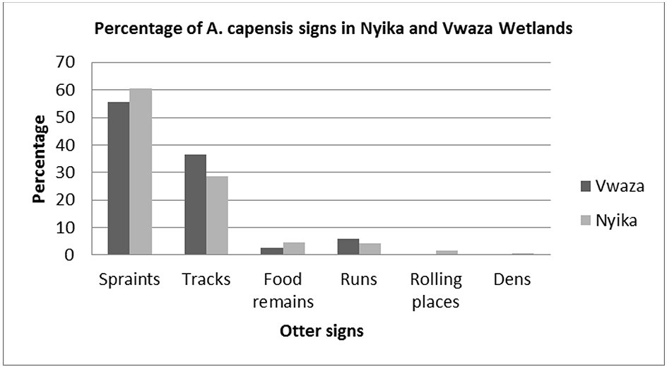 |
| Figure 4. Percentage of A. capensis signs in Nyika and Vwaza Wetlands (click for larger version) |
DISCUSSION
There is evidence of Aonyx capensis occurring in Nyika
National Park and Vwaza Marsh Wildlife Reserve from the surveys that
were undertaken. The majority of the clawless otter signs sighted
were scats (Table
1, Figure 4) in addition to other signs. The
status of the Aonyx
capensis in Nyika could be rated as common whereas in Vwaza it is
sparse. We are well aware of the weakness of otter sign counts but
possibly they are better than nothing. The use of otter signs mainly
spraints is a problematic parameter for indicating the status of
a population (Mason and Macdonald, 1987; Kruuk
et al., 1986). However, the fact
that otter signs occurred in almost all the rivers and streams
surveyed in Nyika National Park, indicates the clawless otter is
common. In Vwaza Marsh Wildlife Reserve, the signs occurred only
in the marsh hence A. capensis is considered to be localized.
The widths of their tracks are almost similar in both protected
areas (Tables
2a, 2c). There was no evidence of occurrence of Spotted–necked
otter in the two protected areas. All sites remained negative. Hough
(1989) indicated that the distribution of the clawless otter is
probably widespread in Nyika and Vwaza whereas the spotted necked
otter is absent. Furthermore, Sweeney (1966) maintains
that the clawless otter in Malawi is more common than the spotted
necked otter and that it occurs in marshy places at lower levels
in small streams while the latter is restricted to larger rivers and
lakes.
A. capensis signs were not sighted in all the three major wetlands in Vwaza Marsh Wildlife Reserve (Table 4a, Figure 2 ). Only the marsh indicated positive signs. Luwewe and South Rukuru rivers remained negative with no evidence of otter occurrence. The finding agrees with the results on the interviews conducted among local fishermen (Table 2b). The primary living requirement for otters in freshwater habitats is unpolluted, unsilted water which contains sufficient numbers of most important food items, crabs and fish. Dense riparian vegetation (long grass, reeds, bushes) is essential to provide cover for resting places and holts (Rowe-Rowe, 1992; Trindade et al., 1995). The habitat in the marsh is ideal for the existence of the species (Table 4a). It is characterized by dense papyrus marsh with patches of bulrush and reeds and a high density of freshwater river crabs and catfish. Crabs, fish and frogs are the major food items for clawless otter (Rowe- Rowe 1977). The main factors of stress are competition for fish and crabs between otters and local fishermen, riparian vegetation destruction, illegal bush fires and streambank cultivation. In Luwewe and South Rukuru rivers including Zaro pool and Lake Kazuni (approximately 50 ha), the habitat is not conducive to the survival of otters. During the dry season, the rivers dry up fast leaving only very small silted water pools. Crabs are very rare also in the rivers. There is high level of human disturbance mainly due to fishing activities. Additionally, streambanks are open with little vegetation cover for otters mainly due to illegal dry season hot fires. Mkanda (1993) showed that fires strongly affect plant growth. South Rukuru floodplain is dominated by a high density of young trees less than one meter high (Mgoola, 1999). It has an open canopy; soils are clayey with medium to high fertility and low to medium soil water infiltration rates (McShane, 1985). These condition favours high grass biomass production that lead to intense fires which burn vegetation along riverbanks leaving them vulnerable to soil erosion.
A. capensis community occurs in Nyika National Park. Signs were sighted in almost all the river and streams surveyed (Table 4b, Figure 3). A total of 790 otter signs were recorded (Table 1) and most occurred frequently in riverine habitats in northern hills, followed by montane riverine habitats on plateau and southern hills. Scats recorded on plateau mostly occurred on river rocks, some on riverbank grasses while those in northern and southern hills were deposited mainly on grasses along riverbanks. The densities of A. capensis signs are higher than in Vwaza Marsh Wildlife Reserve (Table 3). Habitats are ideal for the survival of otters. There is abundant otter prey (fish, crabs), good riverine vegetation cover, continuous water flow and reduced human activity on rivers and streams. There is enough ground to indicate that most clawless otters in Nyika National Park occur in the northern hills wetlands. Abundant otter prey, perennial waters, good bush cover and minimum human disturbances are some of the factors contributing to higher densities of otter signs than the plateau and southern hills wetlands (Table 4b). Fish poaching is the major threat to the survival of A. capensis and can be controlled by regularly patrolling the area. Nyika National Park has high potential for the survival and existence of the clawless otter. Nevertheless increasing stress factors in some sites are threatening the species, illegal bush fires and fish poaching.
CONSERVATION PERSPECTIVES
In order to enhance the survivability of otters and their habitats, the following conservation measures are recommended:
- Illegal bush fires are the common problem in Nyika and Vwaza protected areas. It was observed in almost all the sites sampled. It is essential to implement early burning regimes to reduce dry season hot late fires which are very destructive to all fauna and flora.
- The northern hills wetlands in Nyika support a viable population of A. capensis. Fish poaching is the main stress and regular patrols in the area can assist curb the situation.
- Awareness campaigns among the local communities on the importance of conserving wetlands and their associated wildlife bushfire hazards, streambank cultivation.
- Soil erosion is common on the plateau in Nyika plateau due to illegal fires and roadside drain. This result in high silt load in streams and rivers. Grassland burning programmes should whenever possible leave a buffer strip of unburn vegetation along streams and riverbanks to contain surface wash at the beginning of rains.
- The marsh is potential otter area in Vwaza and such deserves special conservation measures. There is need to control the fishing programme to reduce the otter- human conflicts. Close season fishing period should be developed joinery with local communities. Furthermore, riparian vegetation destruction should be discarded.
- Monitoring of water quality in wetland to check pollution.
- Vwaza and Nyika Research Unit to continue otter monitoring and their habitat. The information reported herein should serve as baseline data for the future management and conservation of Aonyx capensis in Nyika National Park and Vwaza Marsh Wildlife Reserve.
Acknowledgements: The authors wish to express their heartfelt gratitude’s to the Royal Geographical Society of the United Kingdom for the financial support without whose help the task would have been difficult to accomplish. We are indebted to Messer’s G.Y. Mphepo, L.N. Mtumbuka, C.C. Luhanga, M.B. Chione (driver) and the entire Nyika Research Staff for their support and assistance rendered in the field. Finally the following National Parks Officers are thanked for their valuable comments on the paper, C. Manda, G.Y. Mphepo, T.Mhango, R.Kabambe and F. Thenthi
REFERENCES
Bowden, D., Mahto, T. (1999). Freshwater
aquatic surveys. In Overton, MJ (Ed) Biosearch Nyika and the Scientific
Exploration Society Nyika Expedition 1999. pp 64-72.
[available from http://www.biosearch.org.uk/SES%20Report%202000.pdf accessed 30/08/17]
Butler, I.B.A., Hillman, C. (1995). Cape clawless otter (Aonyx capensis) as indicators of water pollution by heavy metals and pesticides in Zimbabwe. IUCN Otter Specialist Group Bulletin 11: 38-47.
Clarke, J.E. (1983). Protected areas master plan for Northern Region. Department of National Parks and Wildlife. Lilongwe, Malawi
Hayslett, H.T., Murphy, P. (1968). Statistics made simple. 3rd ed. W.H. Allen and Co.., United Kingdom.
Hough, J. (1989). Malawi’s National Parks and Game Reserves, pages 174-175.
Husson, S.J., Lowthrop, N.W., Pink, M.J.,
Creegan, L.E., Henderson, I.M. (1997). The distribution and relative
abundance of large mammals within the northern extension of Nyika National
Park.
In Overton, MJ (Ed): Malawi 1997 - A biodiversity expedition
in the northern hills of Nyika National Park, pp 48-67.
Kruuk, H., Conroy, J.W.H., Glimmerveen, U., Ouwerkerk, E.J. (1986). The use of spraints to survey population of otters, Lutra lutra. Biol.Conserv. 35: 187-194.
Mason, C.F., Macdonald, S.M. (1987) The use of spraints for surveying otter Lutra lutra population: an evaluation. Biol. Conserv 41: 167-177.
McShane, T.O. (1985). A baseline ecological survey, Vwaza Marsh Game Reserve, Department of National Parks and Wildlife, Lilongwe, Malawi.
Mgoola, W.O. (1999). Vegetation regeneration study in Vwaza Marsh Wildlife Reserve, Malawi.
Mill, T.A. (1979). Resource inventory and management plan for Nyika National Park. MSc. Thesis, University of Calgary, Alberta, Canada.
Mkanda, F.X. (1993). The effects of prescribed burning on soil and vegetation in Kasungu National Park, Malawi. Nyala 17 (1): 17-22.
Msiska, H.G. (1997). A qualitative assessment of fishes of Vwaza Marsh Ecosystem: As a harvestable resource in Traditional Authority Katumbi, Rumphi, Malawi.
Nagulu, V., Vasudeva Rao, V., Satyanarayana, D., Srintvasulu, C. (1998). Otter records and otter conservation perspectives in Andhra Pradesh, India. IUCN Otter Specialist Group Bull. 15(1): 31-37.
Romanowski, J., Brzezinski, M. (1997). How standard is the standard technique of the otter survey? IUCN Otter Spec. Group Bull. 14(2): 57-61.
Rowe-Rowe, D.T. (1977). Prey capture and feeding behavior of South African Otters. Lammergeyer 23: 13-21
Rowe-Rowe, D.T. (1992). Survey of South African Otters in a freshwater habitat using sign. South African J. Wildl. Res. 22: 49-55.
Rowe-Rowe, D.T. (1993). Otter surveys. A simple and quick method. Natal Parks Board.
Smith, L. (1992). Human impacts in the otter point area of Lake Malawi National Park. Nyala, 17 (1): 1-6.
Sweeney, R.C.H. (1966). Animal life of Malawi. Vertebrates. Volume II: 125-134.
Trindade, A., Farinha, N., Florencio, E., Sousa, M. (1995). Otter Conservation in Portugal - Distribution and status of Lutra lutra in five protected areas of the country. IUCN Otter Spec. Group Bull. 12: 15-18.
Wilson, D.E., Cole, R.F., Nichols, J.D., Rudran, R., Foster, M.S. (1996). Measuring and monitoring biological diversity. Standard methods for mammals. Smithsonian Institution Press, Washington and London
Yoxon, P. (1998). Spraints surveys and sparsely populated otter population. IUCN Otter spec. Group Bull. 15(2): 109-111.
APPENDIX I: Vwaza Marsh Wildlife Reserve Data
| Spraints | Tracks | Spraint site | Den | Run | Rolling Places | Food Remains | |||
| No | Length (mm) | Diameter (mm) | No | Width (mm) | |||||
| 3 | - | - | - | - | 1 | - | - | - | - |
| 28 | - | - | 5 | 90 | 1 | - | - | - | - |
| - | - | - | 3 | 65 | - | - | - | - | - |
| - | - | - | 4 | 70 | - | - | - | - | - |
| - | - | - | 5 | 70 | - | - | - | - | - |
| 15 | 40 | 18 | 2 | 60 | 1 | - | - | - | - |
| 12 | - | - | - | - | 1 | - | 4 | - | - |
| 2 | - | - | - | - | 1 | - | 1 | - | 1 |
| 3 | - | - | - | - | 1 | - | - | - | - |
| - | - | - | - | - | - | - | 1 | - | 2 |
| 3 | 36 | 24 | - | - | 1 | - | - | - | - |
| 4 | 35 | 24 | - | - | 1 | - | - | - | - |
| 3 | - | - | 22 | 35 | 1 | - | 1 | - | - |
| 8 | 70 | 28 | 4 | 30 | 1 | - | - | - | - |
| 10 | - | - | 4 | 35 | 2 | - | 3 | - | - |
| 6 | 70 | 25 | - | - | 1 | - | - | - | - |
| 10 | 75 | 20 | 3 | 55 | 3 | - | 1 | - | - |
| 8 | 60 | 25 | 11 | 65 | 1 | - | 2 | - | - |
| 6 | 55 | 20 | 3 | 45 | 2 | - | - | - | - |
| 8 | 65 | 20 | 16 | 56 | 1 | - | - | - | - |
| - | - | - | 3 | 55 | - | - | - | - | - |
| - | - | - | 2 | 50 | - | - | - | - | - |
| 7 | 85 | 30 | 3 | 60 | 2 | - | 1 | - | - |
| 1 | - | - | - | - | 1 | - | - | - | - |
APPENDIX II: Nyika National Park Data
| Spraints | Tracks | Spraint site | Den | Run | Rolling Places | Food Remains | |||
| No | Length (mm) | Diameter (mm) | No | Width (mm) | |||||
| - | - | - | 9 | 30 | 3 | - | - | - | 1 |
| - | - | - | 4 | 30 | - | - | - | - | - |
| 15 | - | - | - | - | 3 | - | - | - | - |
| 12 | - | - | - | - | 5 | - | - | - | - |
| 12 | - | - | 8 | 30 | 4 | - | - | - | - |
| 5 | - | - | 1 | 35 | 1 | - | 1 | 2 | 2 |
| 20 | - | - | 4 | 35 | 1 | - | - | - | 6 |
| 13 | - | - | - | - | 2 | - | - | - | 3 |
| 8 | - | - | 15 | 70 | 1 | - | - | - | 4 |
| 1 | - | - | - | - | 1 | - | - | - | 6 |
| 18 | - | - | 4 | 50 | 5 | - | - | 6 | - |
| 6 | - | - | - | - | 1 | - | - | - | - |
| 4 | - | - | - | - | 1 | - | 3 | - | 2 |
| 10 | 60 | - | - | - | 1 | - | 1 | - | 2 |
| 6 | 40 | 20 | - | - | 1 | - | 3 | - | - |
| 4 | 35 | 16 | - | - | 1 | - | 3 | 1 | - |
| 65 | 45 | - | -- | - | 1 | 1 | - | 1 | - |
| 20 | - | - | - | - | 1 | 1 | - | 1 | - |
| 2 | - | - | - | - | 1 | - | 2 | - | - |
| 4 | - | - | - | - | 1 | - | - | - | - |
| 1 | - | - | - | - | 1 | - | - | - | - |
| 1 | - | - | - | 2 | - | 1 | - | 1 | |
| 7 | 38 | 23 | - | - | 2 | - | - | - | 2 |
| 5 | 40 | 15 | - | - | 2 | 1 | - | - | 1 |
| 6 | - | - | - | - | 4 | - | - | - | - |
| 3 | - | - | - | - | - | - | - | - | 2 |
| 11 | 45 | 20 | 6 | 35 | - | 1 | - | - | |
| - | - | - | 1 | 32 | 2 | - | - | - | 1 |
| - | - | - | 7 | 55 | - | - | 2 | - | - |
| - | - | - | - | - | 1 | - | - | 1 | 1 |
| 13 | 50 | 20 | - | - | 3 | - | 1 | - | 3 |
| 9 | 30 | 20 | - | - | 2 | - | - | - | - |
| 4 | 70 | 30 | - | - | 1 | - | 1 | - | - |
| 6 | 40 | 25 | - | - | 1 | - | 1 | - | - |
| 14 | 45 | 30 | - | - | 1 | - | - | - | - |
| 11 | 40 | 25 | 4 | 75 | 2 | - | 1 | - | - |
| 22 | 75 | 30 | - | - | 2 | - | 1 | - | - |
| 10 | 35 | 10 | 2 | - | 1 | - | - | - | - |
| 2 | - | - | - | - | 1 | - | 1 | - | - |
| 3 | - | - | - | - | 2 | - | - | - | - |
| 4 | 35 | 15 | 4 | 70 | 1 | - | 1 | - | - |
| 10 | - | - | - | - | 2 | - | - | - | - |
| 6 | 34 | 20 | - | - | - | - | - | - | - |
| 5 | 60 | 15 | - | - | 1 | - | - | - | - |
| 6 | 55 | 15 | 25 | 40 | 1 | - | - | - | - |
| - | - | - | 4 | 50 | - | - | 1 | - | - |
| - | - | - | 2 | 55 | - | - | - | - | - |
| - | - | - | 1 | 55 | - | - | - | - | - |
| - | - | - | 2 | 60 | - | - | - | - | - |
| - | - | - | 2 | 70 | - | - | - | - | - |
| - | - | - | 1 | 50 | - | - | - | - | - |
| - | - | - | 3 | 50 | - | - | - | - | - |
| 12 | 60 | 30 | 4 | 60 | 1 | - | - | - | - |
| - | - | - | 3 | 55 | - | - | - | - | - |
| - | - | - | 1 | 60 | - | - | - | - | - |
| - | - | - | 2 | 55 | - | - | - | - | |
| - | - | - | 5 | 50 | - | - | - | - | - |
| 2 | 30 | 15 | 2 | 50 | 1 | - | - | - | - |
| 6 | 90 | 30 | - | - | 2 | - | - | - | - |
| - | - | - | 1 | 50 | - | - | - | - | - |
| 2 | 50 | 30 | - | - | 1 | - | - | - | - |
| 2 | 30 | 15 | 5 | 50 | 1 | - | - | - | - |
| 7 | 40 | 10 | 4 | 50 | 1 | - | - | - | - |
| 6 | 40 | 20 | 6 | 60 | 1 | 1 | - | - | - |
| 12 | 80 | 20 | - | - | 1 | 1 | - | - | - |
| - | - | - | 4 | 50 | - | - | - | - | - |
| - | - | - | 5 | 51 | - | - | - | - | - |
| - | - | - | 1 | 60 | - | - | - | - | - |
| - | - | - | 2 | 50 | - | - | - | - | - |
| - | - | - | 1 | 60 | - | - | - | - | - |
| 22 | 50 | 25 | - | - | 1 | - | 1 | 1 | - |
| 3 | 25 | 15 | - | - | - | - | - | - | - |
| 2 | - | - | 18 | 70 | 2 | - | 1 | - | - |
| 3 | - | - | 7 | - | 1 | - | - | - | - |
| - | - | - | 13 | - | - | - | 1 | - | - |
| 4 | - | - | 5 | 65 | 1 | - | 1 | - | - |
| 3 | - | - | 7 | 80 | 2 | - | - | - | - |
| 1 | - | - | - | 40 | 1 | - | 2 | - | - |
| - | - | - | 10 | 60 | - | - | - | - | - |
| 1 | - | - | 8 | 75 | 1 | - | 1 | - | - |
| - | - | - | 3 | 60 | - | - | - | - | - |
|
Village:………………………………………………………………….....……………… Fishing locality:………………………………………………………………………...
|
Résumé : Etat des Lieux et Distribution de la Loutre à Joues Blanches (Aonyx capensis) dans la Reserve Naturelle du Marais du Vwaza et du Parc National de Nyika, au Nord du Malawi
La loutre à joues blanches (Aonyx capensis) est présente dans le parc national de Nyika ainsi que dans la réserve naturelle du marais de Vwaza au nord du Malawi. Des recherches d’indices (excréments, pistes, tanières, parcours, restes de nourriture) sur la présence de loutres sont menées dans d’autres rivières, ruisseaux, et zones humides. Le statu de cette espèce peut être considéré comme commun au Nyika et clairsemé au Vwaza. En effet au Nyika, cette loutre est communément présente car toutes les zones humides sous surveillances montrées des signes positifs quant à la présence de loutre. Un total de 790 indices fut enregistré dans le parc national de Nyika, et ces indices ont été le plus souvent retrouvés dans des habitats aquatiques proches de rivières et de ruisseaux dans les collines du nord suivi de ceux présents dans la montagne et sur le plateau, et finalement dans les zones hune au sud. Aucune différence significative concernant la densité de loutres n’a été observée au sein des différentes zones humides du Nyika (F=2.636 df= 2 and 6; P˂0.001). Cette zone géographique possède un fort potentiel pour la survie de ces loutres à joues blanches. Les proies (poissons et crabes) y sont abondantes, la couverture végétale, l’eau et la faible activité humaine y sont adéquates. Aonyx capensis n’a été recensées que dans les marais de la réserve naturelle de Vwaza (247 indices) avec de très rares cas en aval. Les rivières de Luwewe et du sud de Rukuru restent négatives quant à la présence de loutres. Ce marais est un habitat idéal pour la survie et l’existence de ces loutres avec une couverture végétale, de l’eau et des proies adéquates. Les menaces principales observées dans le parc national de Nyika sont les feux de brousse illégaux, la pêche illégale en particulier dans les zones humides dans les collines du nord, et l’érosion des sols. Concernant la réserve naturelle des marais du Vwaza les facteurs majeurs de stress sont la culture des berges, la destruction de la végétation riparienne, envasement, les feux de brousse illégaux et la compétition vis-à-vis des hommes quant aux poissons et aux crabes. De vastes mesures de conservation sont proposées pour une survie et une existence à long terme des loutres à joues blanches et de leurs habitats.
Revenez au dessus
Resumen: Status y Distribución de la Nutria sin Garras (Aonyx capensis) en la Reserva de Vida Silvestre del Pantano de Vwaza, y el Parque Nacional Nyika, Norte de Malawi
La nutria sin garras (Aonyx capensis) está presente en el Parque Nacional Nyika y la Reserva de Vida Silvestre del pantano de Vwaza, en el Norte de Malawi. Realizamos búsqueda de signos de la nutria (fecas, huellas, madrigueras, rastros de deslizamiento, restos de comida). El status de la especie en Nyika podría ser clasificado como común, y escaso en Vwaza. La nutria sin garras aparece en forma común en Nyika; todas las áreas de humedal prospectadas indicaron signos positivos. Registramos un total de 790 signos en el Parque Nacional Nyika; estos signos fueron registrados más frecuentemente en hábitats de ríos en las colinas del norte, seguidos por hábitats de ríos montanos en los humedales de las mesetas y las colinas del sur. No hay diferencia significativa en la densidad de nutrias en los humedales de Nyika (F=2.636 df=2 y 6; P˂0.001). Este área tiene un alto potencial para la supervivencia de la nutria sin garras. Hay abundantes presas (peces, cangrejos), adecuada cobertura vegetal, agua, y poca actividad humana. Aonyx capensis en la Reserva de Vida Silvestre del pantano de Vwaza fue registrada solamente en el pantano (247 signos), y muy raramente en las áreas aguas abajo. Los ríos Luwewe y Rukuru del Sur permanecieron negativos, sin evidencia de ocurrencia de nutrias. El hábitat en el pantano es ideal para la supervivencia y existencia de las nutrias, con adecuada cobertura vegetal, agua y presas. Las principales amenazas observadas en el Parque Nacional Nyika incluyen incendios ilegales, pesca furtiva especialmente en los humedales de las colinas del norte, y erosión del suelo. Los principales factores de stress en la Reserva de Vida Silvestre del pantano de Vwaza son los cultivos en las costas de los arroyos, destrucción de vegetación ribereña, sedimentación, incendios ilegales, y competencia por los peces y los cangrejos entre los humanos y las nutrias. Se proponen medidas amplias de conservación para la supervivencia y existencia a largo plazo de la nutria sin garras y sus hábitats.
Vuelva a la tapa